Figure 1. Map of northern Botswana, showing the location of the crater.
J. Brit. Astron. Assoc., 107, 2, 1997, p. 72–74
by Colin Henshaw
A brief note on a crater-like formation in the Okavango Delta, Botswana, about 35km north of the popular safari centre Maun.
In August 1993 I was interviewed at Delta Waters International School, Botswana, for a two year contract as a science teacher. During the interview I was informed of a 'meteorite crater' located in the bush somewhere in the Okavango Delta. I suggested that it would make an excellent science club project to investigate it, and that I would follow it up if appointed. I was offered a contract at the school, and took up my appointment in January 1994. Before returning to Botswana, I purchased a small metal detector to use in the investigation.
Two stories are associated with the feature which unfortunately seem to conflict with each other, and it has not been determined which is nearer the truth. The first story tells that it occurred on 1978 August 12 at 12.30 local time, and that it was associated with a fireball and a seismic event. Whether it occurred in daytime or during the night was not made clear. Unfortunately for this story, it must be pointed out that Maun is seismically active, being associated with the African Rift Valley system, and that minor earthquakes are not uncommon. The second story was told by a safari operator who said he discovered the crater in the early 1950s when he first arrived in the country, and that it was known to local people long before that. He said they were aware of it during the 1930s and that again it was associated with a fireball event. Later, when I mentioned this to the person who was the source of the first story, I was told that the safari operator was not in the country at the time he claimed to have found it. It appears someone somewhere is not telling the truth, but why this should be is unknown.
Figure 1. Map of northern Botswana, showing the location of the crater.
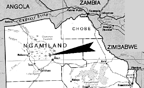
An expedition was organised with a local person who knew the location of the crater, and was set for 1994 April 23. The feature is located in an area known as Khurunxaraga, not far from Beacon and Bobo Islands in the Okavango Delta (Figure 1). The approximate co-ordinates are 23°20'E, 19°50'S. Although it is only 35km north of Maun, the feature is in an isolated area accessible only by a four-wheel drive vehicle. The road was very poor, being nothing more than a dirt track, and this resulted in a journey time of about 2hrs 45m. The crater is located beyond the Buffalo Fence, which was installed to keep wild and domestic animals separate. Once beyond the Buffalo Fence, the bush becomes thicker as it is not overgrazed by the goats kept by the Batswana in large numbers. On the far side of the Buffalo Fence wild animals such as giraffes and elephants became common, and even a pair of male lions were seen.
The feature is located close to the road leading from the Buffalo Fence but is invisible from it due to the thick vegetation. A tour guide who knows the area is essential if the crater is to be found. On our arrival we found that the crater was perfectly circular and saucer-shaped, and had a very slightly raised rim. It was found to be about 22 metres in diameter, and about 3.5 to 4 metres deep. (The measurements were made with metre rules, tape measures and string.) The sides of the feature had suffered a certain amount of gullying, and we were told that the centre had filled in over recent years. The sides of the crater were devoid of vegetation, which can be seen in the accompanying photo-mosaic (Figure 2), but there was a considerable amount of grass growing in the middle. The material in which the crater was excavated appeared to be soft calcrete, a substance formed under desert conditions which is common in the Kalahari area. The soil around the crater was sandy. My students swept the crater inside and out using the metal detector, but no metallic objects of any kind were found. There was no evidence, either, of any stony material, apart from the usual calcrete which was found everywhere. Calcrete is a conglomerate material formed by the cementation of sand and gravel with calcium carbonate.
It was essential to determine whether or not the feature was artificial or natural in origin. The structure appeared to be perfectly circular, and no evidence was found for excavated material heaped around the edges. Such material would almost certainly be present if it were a simple hole dug into the ground. People digging a hole would tend to heap the excavated material randomly around the rim, but there was no evidence for this. The location has always been very isolated, and no reason could be thought of as to why local people would want to excavate such a hole.
It was then suggested that the feature might be a bomb crater. However, the Botswana Defence Force has not been active in the area. Richard Fleet recently postulated that the South African Defence Force may have off-loaded unused bombs in the area after bombing raids on Angola during the late 1970s. The area is very isolated, so such activity would not likely be noticed. However, to produce a crater this size would require a very large bomb, and one would expect to find shrapnel in the area if this were in fact the cause. The results of the investigation using the metal detector did not reveal any metallic objects whatsoever, so it was generally felt that this explanation could be discounted.
This then leaves natural causes. It has been suggested that the feature may be some form of 'sink holeŐ or subsidence feature. If so, then one would expect more features of the same type throughout the region. This is not the case and the feature appears to be unique.
In terms of the local geology the Okavango River is one of the few inland drainage systems in the world, and certainly one of the largest. The river comes down from Angola, bringing with it flood waters after the end of the rainy season. The river originally entered a large lake in central Botswana, but faulting and uplift altered the general lie of the land and blocked the river near Maun. The Thamalakane Fault marks the start of the Delta, and is connected to the African Rift Valley system. The blockage caused by the fault caused a build-up of alluvial deposits brought down by the river, resulting in a large delta composed of numerous islands and channels.
The bedrock below the Delta and most of the Kalahari underlies several hundred feet of Kalahari Sand. It is largely unexplored, but where it does come to the surface reveals very old Pre-Cambrian material such as that found at the Tsodilo Hills, and in the Tswapong Hills. Much of this material consists of schists, gneisses, quartzites, and sandstones. Diamond-bearing Kimberlites exist at Orapa and Letlhekane where diamonds are extracted commercially.
Maun is siesmically active, and earthquakes have occurred from time to time. One shake in the 1950s was strong enough to crack buildings. However, the extensive depth of Kalahari Sand cushions the effect of the earthquakes so that most of them are not noticed.
Rainfall in Botswana is very seasonal, and even during the rainy season it is spasmodic. Torrential late afternoon storms are the general pattern, but extended periods of no rainfall are common. The region is prone to droughts, and there is little productive agriculture. Cattle rearing is the main activity, and the indigenous population will often go into the bush to look after their herds on their 'cattle posts'. It is unlikely that the crater would ever fill up with water, though puddles are likely to form at the bottom of it after a heavy shower. It was certainly very dry when visited, and no evidence was found for extended periods of flooding. No aquatic organisms (such as fresh-water snails) were found to support this. The floor of the crater was scrutinised for animal life, and apart from the occasional insect, nothing significant was found. However, the possibility of temporary flooding after storms is supported by the fact that the internal ramparts of the crater showed strong evidence of gullying.
The general consensus of opinion amongst those who have visited the site is that it is a meteorite crater. Photographs were submitted to Neil Bone of the BAA Meteor Section, and to Colin Pillinger at the Open University in Milton Keynes, and they could not rule out the possibility. It was pointed out that a relationship exists between the size of a crater and the size of the object creating it, such that the impacting object will create a hole about ten times its own diameter. If an impact explanation is correct, then an object around 2 metres across was responsible. It need not have been metallic, and it almost certainly buried itself deep below the ground. If the object's trajectory came in at an angle, then it is probably not located under the crater, but more off to one side. Colin Pillinger pointed out that a large meteorite recovered in China had excavated a hole 28 metres across and six metres deep.
It was generally felt that if the feature is a genuine impact crater, then it is worth preserving as it is. Any attempt to recover the meteorite would cause irreparable damage to the crater, and would be very difficult anyway due to its isolation. The crater is located in a conservation area and would be an added attraction for the tourist industry. However, to reduce the effects of erosion and to maintain the crater in its present condition, visitors should be discouraged from going inside it.
I am grateful to Andreas Amundsen, Niels Olsen, Andreas Reiensen, Stephen Ridge, and Jakob Sřrensen for their invaluable assistance during this investigation.
Colin Henshaw, 10, Delamere Road, Gatley, Cheadle, Cheshire, SK8 4PH, UK
Back to top of page
Return to Journal 1997 April contents page